 The eruptive activity at Holuhraun continues at similar intensity. Lava flows to the East at similar rates as yesterday. The lava is now flowing in the river bed of Jökulsá á Fjöllum. No explosive activity due to the lava and river water interaction has been observed, but steam rises from the lava.
Around 150 earthquakes have been recorded since midnight to noon. The largest two earthquakes, 3.8 and 5.2 in magnitude occurred on the northern rim of Bárðabunga Caldera. Small but continuous low frequency tremor has been observed for the last few days. GPS observations show insignificant crustal movements supporting the assumption that the amount of magma flowing into the dyke continues to be similar to the magma erupted to the surface.
Air quality
Air quality in urban areas in East of Iceland: Concentrations of SO2, comparable to those measured Saturday in Reyðarfjörður, may affect people with underlying respiratory problems although others should not experience any significant discomfort. Efforts to increase the gas monitoring in inhabited areas are on-going. Data from newly installed SO2 monitoring stations will be accessible later today. Yesterday 8th September no chemical pollution, related to the eruption, was detected and none is expected today. Instructions from the office of the Chief Epidemiologist and The Environmental Agency can be found on their web-sites www.landlaeknir.is and www.ust.is . Air quality at the eruption site: Gas emissions at the eruption site remain high. As local gas concentrations at the site can be life threatening, people at the eruption site should wear gas masks and gas meters. Scientists on the site, have had to leave the area repeatedly as concentrations of gas reached dangerous levels, due to sudden changes in wind conditions. At the eruption site local wind anomalies can occur due to thermal convection from the hot lava. This makes the conditions on site extremely dangerous as winds can change suddenly and unpredictably.
Precautionary measures
Efforts to increase the gas monitoring in inhabited areas are on-going, by The Environment Agency of Iceland.
The closures and restrictions of the area north of Vatnajökull are still in force. All roads leading into the area are closed except for scientists and media that have had limited access the Civil Protection with special permit and any attempts to go into the eruption site without permission are met with fines. As Sulphur dioxide emission continues, The advice of Administration of Occupational Safety and Health for all institution and companies working in the area is to conduct a risk assessment and response plans according to regulation (nr. 920/2006).
The road to Dettifoss on the West side of Jökulsá á Fjöllum (No 862) is opened for traffic from the ringroad 1 to the Dettifoss waterfall. Other roads on the west side are still closed, including hiking trails. All roads leading to the volcanic site are closed, based on the risk of a flood if an eruption will start under the glacier. Information on closures can be found on the Icelandic Road and Coastal Administration web page: http://www.vegagerdin.is/media/umferdog-faerd/Halendi.pdf
The Aviation Colour Code for Bárðarbunga remains at ‘orange’ and the code for Askja at ‘yellow. The Civil Protection Alert phase is in effect.
Risk assessment
It remains unclear how the situation will develop. Four scenarios are considered most likely:
- The migration of magma could stop, resulting in a gradual reduction in seismic activity and no further eruptions.
- The dyke could reach the Earth’s surface at different locations outside the glacier. Lava flow and/or explosive activity cannot be excluded.
- The intrusion again reaches the surface under the glacier leading to a significant sub-glacial eruption. This would most likely produce a flood in Jökulsá á Fjöllum and perhaps explosive, ash-producing activity.
- An eruption in Bárðarbunga. The eruption could cause an outburst flood and possibly an explosive, ashproducing activity. In the event of a sub-glacial eruption. Flooding would most likely affect Jökulsá á Fjöllum, but it is not possible to exclude flood paths to Skjálfandafljót, Kaldakvísl, Skaftá and Grímsvötn.
Risk of floods
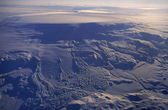
There is still a risk of flood in the area. This is based on the fact that an eruption may begin under the Vatnajökull glacier, either in Dyngjujökull or Bárðarbunga caldera.
Cooperation and coordination
The coordination of the operation and information continues at the National Crisis Coordination Center (NCCC). This morning there was a meeting with the Icelandic Civil Protection Scientific Advisory Board, followed by a teleconference with the District Commissioner in Húsavik to coordinate measures. Also there have been collaboration with Vatnajökull National Park on restrictions, traffic and environmental protection. Representatives from the Environmental Agency, the Chief Epidemiologists, the Earth Science Institute of the University of Iceland and the Meteorological Office will coordinate their work, monitoring gas emitted from the eruption, as well as prevention and preparedness. The local Civil Protection authorities in southern Iceland met today with the Department of Civil Protection and Emergency Management, The National Power Company of Iceland and Landsnet (the Electricity transmission grid) analyzing the risk of flooding and different flooding scenarios from Bardarbunga.
Tourist information
Most roads in Iceland are open and accessible including the Ring road (nr. 1) around Iceland and safe for travelling. However, due to the volcanic eruption in the area north of Vatnajökull glacier, the highland north of Vatnajökull glacier is closed for all traffic. The eruption site is about 120 km south of road nr. 1 in northeast Iceland. A live webcam of the eruption can be found at www.livefromiceland.is . All airports in Iceland are open.
Information
A media unit is placed at the National Crisis Coordination Center, providing information and dealing with media requests. The email address is info@sst.is Tel: +354-5702644/43 and webpage for Bárðarbunga and the eruption north of Vatnajökull is www.avd.is/en. The website on safe travel in Iceland is updated regularly: www.safetravel.is

