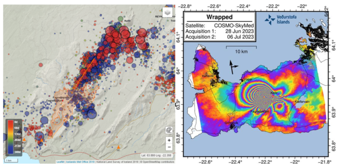
Earthquake activity in the Fagradalsfjall area of the Reykjanes Peninsula has caught the attention of scientists and residents alike. Since the initial seismic activity began on July 4th, a staggering 4,700 earthquakes have been recorded, indicating a potentially significant geological event taking place beneath the surface.
The latest update on July 6th, at 6:00 PM, revealed the findings of a COSMO-SkyMed interferogram, a satellite image showing ground deformation caused by a new dike intrusion that commenced on July 4th. The image displays a series of multicoloured fringes centred between Fagradalsfjall and Keilir, clearly illustrating the extent of ground deformation. The maximum observed deformation, measured in the satellite’s line-of-sight, reaches up to 18 cm in the northwest direction.
It is important to note that while the deformation signal covers a large area of the western Reykjanes Peninsula, it does not necessarily indicate the presence of magma beneath the entire region. The magma intrusion is confined to the area between Fagradalsfjall and Keilir, with no indications of additional movements outside this specific region.
The interferogram also reveals several small lineaments intersecting the fringes, representing fault movements and earthquakes triggered during the dike propagation. These seismic events further emphasize the dynamic nature of the ongoing geological activity.
In the most recent update on July 6th, at 12:30 PM (from the Icelandic Met Office), it was reported that the earthquake swarm on the Reykjanes Peninsula continues unabated. Since midnight of that day, over 1,300 earthquakes have been detected, bringing the total number of earthquakes to over 4,700 since the swarm began on July 4th. Several earthquakes measuring over magnitude 3.5 have occurred, with the strongest tremors still being felt in the country’s southwest. While the overall intensity of the swarm has slightly decreased in terms of both the number of earthquakes and their magnitudes, the situation remains concerning.
The spatial distribution of earthquake epicentres forms the northeast-southwest lineament between Fagradalsfjall and Keilir, primarily concentrated just north of the mountain Litli Hrútur. Recent ground deformation observations using GPS technology indicate significant movements, suggesting magma propagation in the highly concentrated earthquake zone. Experts believe that a northeast-southwest trending magma intrusion at a depth of 2 to 4 km is the likely explanation. What is worrying is that the intrusion is close enough to the Earth’s surface that a volcanic eruption could occur without any further escalations in seismic activity or ground deformation.
Based on the current assessment, two possible outcomes are anticipated. The first is a gradual decrease in seismic activity without magma reaching the surface. The second possibility is that the seismic activity will decrease when the magma stops moving laterally but begins to ascend towards the surface, similar to what was observed before the previous two eruptions in the area. An eruption close to the current seismicity concentration is likely in this scenario. However, it is crucial to note that magma reaching the surface anywhere within the region between Fagradalsfjall and Keilir cannot be ruled out. Of the two outcomes, the occurrence of a volcanic eruption within the coming days or weeks is considered more probable.
While the earthquake swarm persists, the main hazard lies in the strong seismic ground motion generated by the largest earthquakes in the sequence and the potential for triggered earthquakes on nearby faults. The largest earthquakes recorded thus far have caused localized rockfalls, prompting authorities to advise against walking near rock cliffs or steep slopes near Keilir, Fagradalsfjall, and Kleifarvatn.
The situation in the Fagradalsfjall area remains closely observed by scientists and authorities. Continuous monitoring and analysis of seismic activity, ground deformation, and other geological indicators are being conducted to provide timely warnings and ensure the safety of residents in the region.

