Volcanic and Seismic Activity:
From the Icelandic Civil Protection Scientific Advisory Board this morning:
Volcanic activity:
The volcanic eruption in Holuhraun continues with similar rate as yesterday.
Seismic activity:
Seismic activity has been rather intensive over the last 24 hours. Yesterday 13 earthquakes larger then M3, 0 were detected in Bardarbunga. The biggest was M5, 2 at 18:09 last night. In total 7 earthquakes larger
then M3, 0 were detected since noon yesterday. Smaller earthquakes were detected in Dyngjujokull glacier and in north part of the dyke.
GPS monitoring continue to show irregularity in the crustal movements over the last few days. This sign could indicate that the magma movement under Bardarbunga is changing.
Air quality
A prediction from the Icelandic Met Office: Today (Thursday) gas pollution is expected in the north central highlands and northwest to Skagafjörður and Húnaflói. Tomorrow (Friday) pollution is expected in north Iceland
from Strandir to Eyjafjörður, in north central highlands and in east Iceland from Hornafjörður north to Egilsstaðir.
A larger pollution area cannot be ruled out. Valid until midnight tomorrow, Friday. The Icelandic Met Office has published an interactive map showing gas pollution prediction. The map can be found here: http://brunnur.vedur.is/kort/calpuff/2014/09/18/00/calpuff_island_so2.html The Icelandic Met Office has also opened a web page were people can report if they have detected gas pollution. A link to the page can be found on the Icelandic version of the web page under Skrá mengun. Few notifications have been registered of the page, including reports from the Westfjords.
Precautionary measures:
Increased monitoring of SO2 and guidelines for the public to follow during the eruption:
People who feel discomfort are advised to stay indoors, close their windows, turn up the heat and turn off air conditioning. Use periods of good air quality to ventilate the house. Measurements of air quality can be found on the webpage www.loftgaedi.is The Meteorological Office issues forecast on its web-page and warnings if conditions change to the worse. Instructions from the Office of the Chief Epidemiologist and The Environment Agency can be found on
their web-sites www.ust.is and www.landlaeknir.is The Icelandic Met Office will publish forecast for sulphuric gases dispersion on the web and in the national radio. It will also be endeavored/seeked to broadcast the forecast on national television. The Environment Agency is working on getting more measuring equipment to better monitor the gases coming from the volcanic eruption.
The Environment Agency is especially looking for information from people who have been in contact with high concentrations of gas; where they were, at what time it happened, how the gas cloud looked (colour and thickness of the cloud) and how they were affected by it. In the near future, there will be a page on the IMO’s webpage for this type of information.
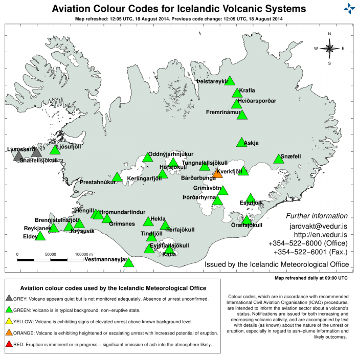
The Aviation Colour Code for Bárðarbunga remains at ‘orange’ and the code for Askja at ‘yellow. The Civil Protection Alert phase is in effect.
Risk assessment
Three scenarios are considered most likely:
The eruption on Holuhraun declines gradually and subsidence of the Bardarbunga caldera stops.
Large-scale subsidence of the caldera occurs, prolonging or strengthening the eruption on Holuhraun.
In this situation, it is likely that the eruptive fissure would lengthen southwards under Dyngjujokull, resulting in a jokulhlaup and an ash-producing eruption. It is also possible that eruptive fissures could develop in another location under the glacier.
Large-scale subsidence of the caldera occurs, causing an eruption at the edge of the caldera. Such an eruption would melt large quantities of ice, leading to a major jokulhlaup, accompanied by ashfall.
Other scenarios cannot be excluded.
Risk of floods:
There is still a risk of flood in the area north of Vatnajökull.
Cooperation and coordination:
The coordination of the operation and information is at the National Crisis Coordination Center (NCCC). Every morning there have been meetings in the Icelandic Civil Protection Scientific Advisory Board to evaluate the situation. This
morning there was a teleconference with local authorities and District Commissioners in Húsavik, Seyðisfjörður, Eskifjörður, Hvolsvöllur and Selfoss. The Chief Epidemiologist and the Environment Agency coordinate the monitoring
and response to gas pollution and information to the public. The National Crisis Coordination Centre has issued temporary permits for scientists and the media to enter the restricted area, subject to certain terms. Also, there have
been meetings with the Icelandic Tourist Industry Association, Icelandic Tourist Board and the Department of Civil Protection and Emergency Management.
Tourist information
Most roads in Iceland are open and accessible including the Ring road (nr. 1) around Iceland and safe for travelling.
However, due to the volcanic eruption in the area north of Vatnajökull glacier, the highland north of Vatnajökull
glacier is closed for all traffic http://www.vegagerdin.is/media/umferd-og-faerd/Halendi.pdf. The website on safe
travel in Iceland www.safetravel.is is updated regularly and so are their information screens aroun

